Did you know?

- Ireland has more than 12,000 lakes.
- Lough Corrib is the largest lake in the Republic of Ireland and contains around 800 billion litres of water, which is enough to fill more than 300,000 Olympic-sized swimming pools.
- Lakes and reservoirs are the main sources of drinking water for two million people in Ireland.
- The EPA currently reports on the ecological health of over 200 lakes. This information helps us understand and manage this freshwater resource.
- Lake water quality in Ireland is better than the European average, but there is no room for complacency. The water quality at almost half of our monitored lakes is categorised as being at ‘moderate’ or worse status.
National Lake Monitoring Programme
A total of 224 lakes are currently included in the EPA’s national surface waters monitoring programme. This covers around 80% of the surface area of all lakes in Ireland.
This monitoring programme includes:
- Lakes greater than 50 hectares
- Lakes that are used for supplying drinking water
- Lakes that are of regional, local or scientific interest
The location and number of lakes on the monitoring programme reflect the distribution of lakes nationally.
What is monitored?
Each lake is monitored for a range of different plants and animals, including:
- Phytoplankton (tiny, free-floating plants)
- Diatoms (type of algae)
- Aquatic plants
- Invertebrates
- Fish (monitored by Inland Fisheries Ireland)
The lakes are also monitored for chemical and physical parameters. The chemical and physical parameters measured in the field and laboratory include:
- Nutrients such as nitrogen and phosphorus
- Dissolved oxygen
- Temperature
- Water clarity
- Colour
The hydrological parameters include water levels.
The plants and animals are monitored once every three years while the physical and chemical parameters are measured several times a year.
Other changes recorded include any change in:
- Physical structure of the lakeshore
- Lake water level
- How much water is flowing into or out of the lake
For technical information on our survey methods and our detailed monitoring programme, please see our report.

Lake water assessment
Ecologically healthy lakes are an important natural resource. Healthy lakes are important:
- For plants and animals that live in, on or depend upon the water
- As a source of clean water for domestic, agricultural and industrial use
- For tourism and recreational activities
In recent years, the water quality of lakes has largely been maintained due to:
- Improvements in wastewater treatment systems
- Better water quality management practices
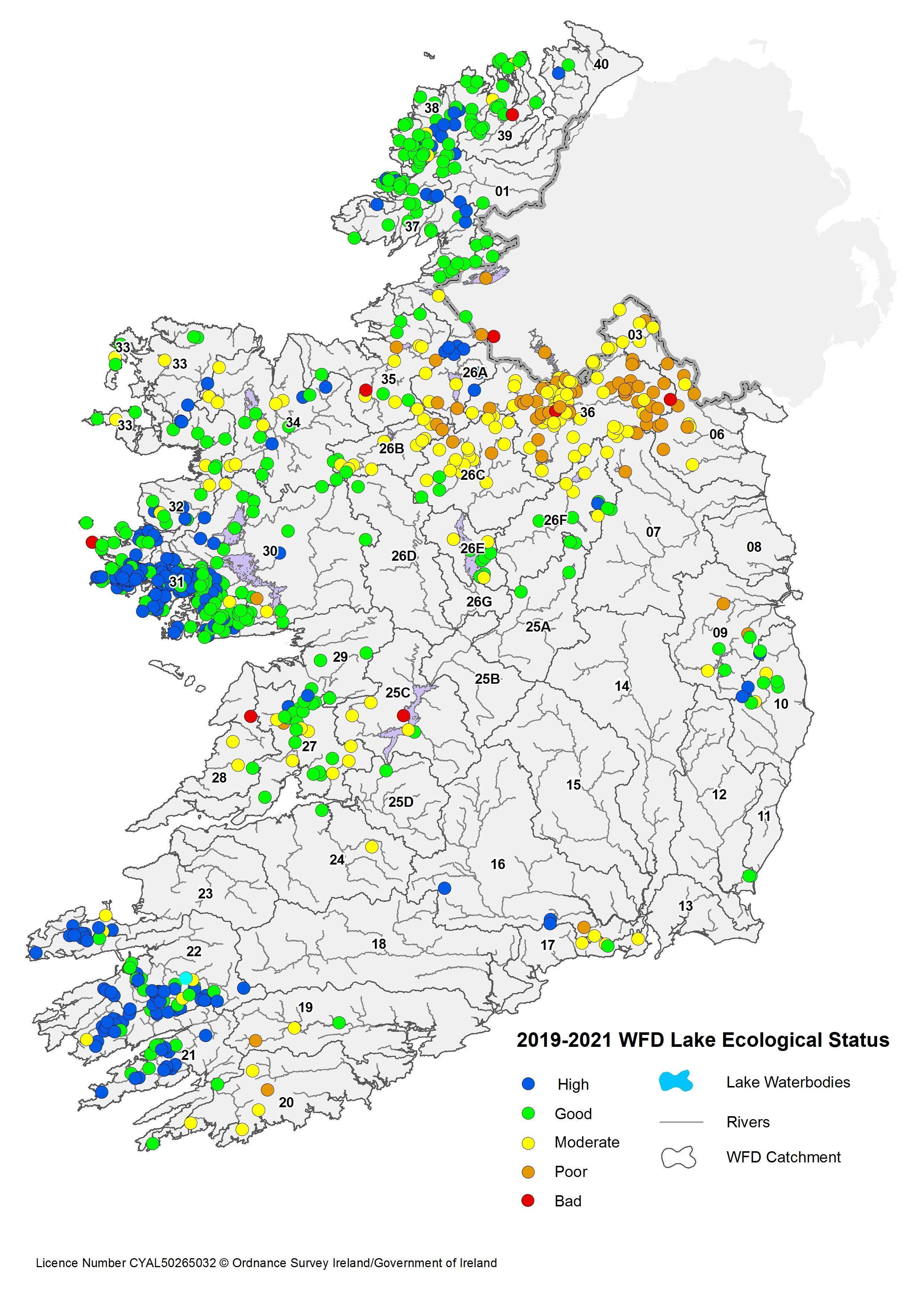
However, there are still significant challenges. Nationally, 557 lakes (69%) are in ‘good’ and ‘high’ ecological status, while the remainder are at less than good (31%). This includes both monitored and unmonitored lakes.
The majority of high and good ecological status lakes are found in the southwest, west and northwest of the country while the majority of moderate or worse ecological status lakes are located in the northeast of the country. This distribution tends to reflect the difference in the level of human activity, hydrogeology and soil conditions in these regions.
The ecological status of lakes in Ireland

The ecological status of rivers in Ireland 2016 to 2021 with hydrometric areas numbered.
See more about lake water quality and environmental pressures on:

Catchments.ie
Catchments.ie shares science and stories about our waters. This includes the Catchments Newsletter, detailed assessments for our 46 catchments and 583 subcatchments, downloadable chemistry data, and dashboards for an overview of status, pressures, impacts and objectives.
-500x262.webp)
EPA Maps
EPA Maps enables you to view environmental information interactively on a map. It includes the latest data on water quality.